

Weston & Sampson is in the process of executing an important project for the city of Boston to help guide curbside electric vehicle (EV) charging station installations within the city and help meet their greenhouse gas (GHG) emissions reductions target.
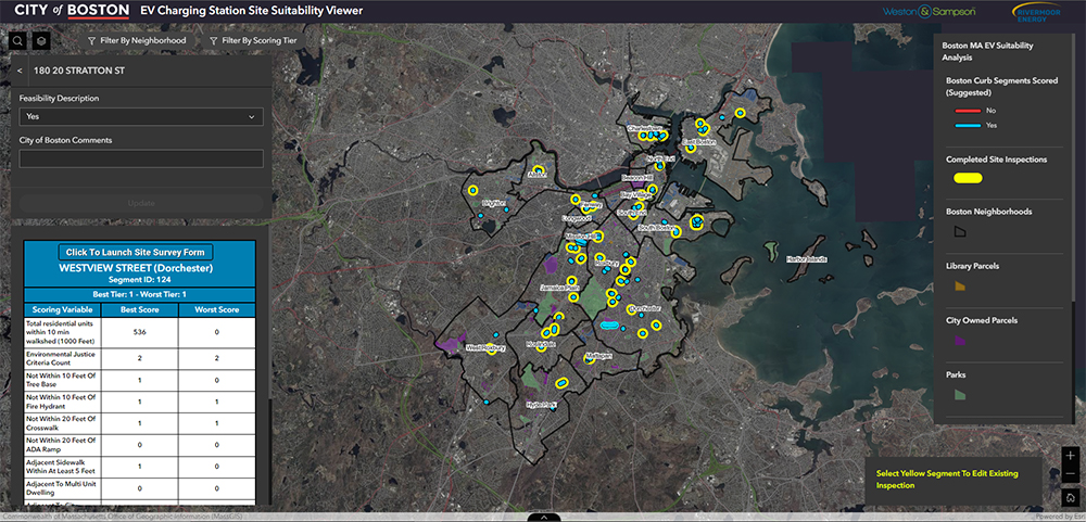
The project goals include identifying 30 suitable curbside locations throughout the city for successful EV charging station implementation. The city has some 1,500 miles of curb, so selecting suitable sites would require a process to filter that sum down to just 0.5 miles, or about 0.0003% of the total curb length in the city. To help the city meet their aggressive goals, we first developed a sophisticated GIS mapping product which analyzed locations throughout the city for suitability. Site examination consisted of an analysis of location, network connectivity, and geometry characteristics, with each being further considered as inclusionary or exclusionary. Conditions favoring inclusion would raise a site’s score, while those that were exclusionary would diminish it. For example, proximity to high-density dwellings or points of interest such as parks and museums raised the score of an individual site, while exclusionary criteria like no parking zones around hydrants diminished the score. Other inclusionary criteria included a site’s location within environmental justice communities; its proximity to public transportation like bus, rail, and bike share locations; its proximity to specific high-traffic public transit hubs; and the availability of mounting structures such as light poles that would facilitate locating charging infrastructure out of existing paths of travel. Other exclusionary criteria included obstructions like trees, designated no parking spaces, planned capital improvements to public transit, on-street dining, historic landmarks, and others.

The analysis for each site reviewed its accessibility to walking paths including the roads, sidewalks, and paths that surrounded it. Curb segments, once divided appropriately based on the minimum required length and offsets from exclusionary zones, were subjected to a process that produced an intermediate dataset describing the theoretical limits of a 10-minute walk to or from that site. This was combined with data on population from census and assessor’s data to understand the potential total population served by any given site. The greater this number, the higher the score of the segment. Additionally, conditions on geometry of the curb segment needed to be evaluated. For example, each site was required to have a minimum length of curb capable of supporting a desired minimum number of vehicles. But also, curb segments needed to be relatively straight to accommodate multiple vehicles. For each segment, therefore, an index of each site’s curvature was calculated that described this quality, allowing for the quantitative evaluation of the site’s applicability.
Each of these criteria were separately evaluated for every potential segment of curb. Criteria were distilled to a score and summed for each segment and allowed us to prioritize field investigations. Maps and applications were developed that allowed the field investigators to collect observed condition information like photographs and store that information in a live database that was updated with each site visit. All of this analysis was shared with the city during the evaluation process in a collaborative, web-based application that updated stakeholders on the progress of the analysis.
This provided the city with an actionable understanding of both where to site its EV charging projects and where grant-qualifying Direct Current Fast Charging (DCFC) sites may be potentially located in the future. This involved identifying the city-owned properties that were appropriate for candidate sites, as well as the city’s existing EV charging stations.
In addition to the GIS mapping task, relevant sources of funding were also identified, and we helped the city submit its applications to Eversource’s “Make Ready” program. This included engineering support for the Make Ready applications, state EVIP grants, and tax credits for eligible EV charging projects. This will reduce and support the capital costs of the build-out of Boston’s EV charging network.
Upon completion, the city of Boston will have taken a major step forward in reaching its goal of having a public EV charging station within a 10-minute walk of every household, located in key areas throughout the city and representing each neighborhood.
Dan Shinnick, GISP, is a GIS team leader in the Reading, Mass. office; Johanna Hall, EIT, CEM, is an energy senior team leader in the Manchester, N.H. office of Weston & Sampson.